 |
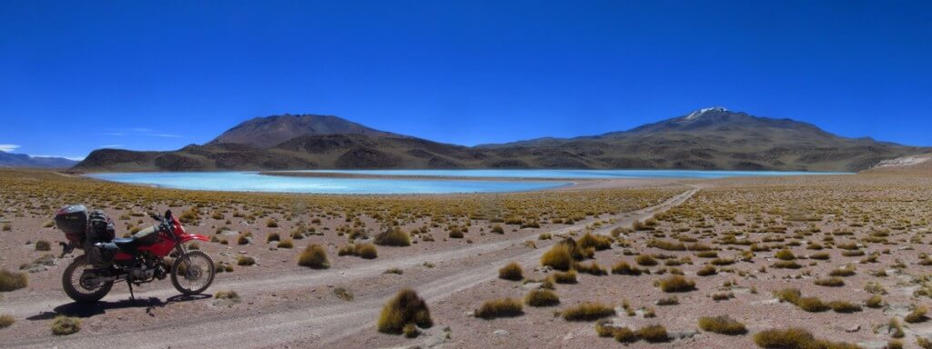
| Heading to Laguna Celeste, the Lagunas Route, Bolivia |
 |
| Valle de Rocas |
The wind charges through like rushing ghosts and the red rock reaches out of the ocean of sand like hands and waves fighting against the tide. The tent, for once, is cosily placed, embraced and shielded by one of these tall red waves of rock, out of ghostly reach.
I turn off the stove and pour the hot water on a tea bag before turning to my book. A lizard scurries along the course sand and I look up to see him curl between the cooling stove and a warm rock. His skin is the colour of pebbles and he looks back to me with innocent black eyes as with his quick forked tongue he tastes the air. It tastes of tea and feet. I move for my hot cup of sweet tea and he scurry-scurries away to back from where he came. I turn back to my book and before reaching the very same line on the page, he is there again…..and then again, always the same spot.
“You’re a brave fella, aren’t you…..curious at least….hey, you’re not coming in my tent are you?”
Considering this perhaps, the lizard looks for a while longer, before this time courageously scampering quickly around and behind the tent, out of sight. He must be going home, for the sun is beginning to set. I think about reading the same sentence in my book for the umpteenth time, but with the temperature dropping, so too is the wind; time to go off and get some photos.

Walking, I watch as the rock turns deeper and deeper orange and the sky morphs into a huge and spotless dome of violet. I take pictures of the colourful waves of rock as the shadows rise up from the ground and the world vanishes for the night.
When I return to the tent, the light-show over, I can’t seem to settle my mind enough to relax and read; perhaps it’s the stone claw hanging over my tent waiting to fall and maul me. But no, it’s not that. I’m camping in the Valle de Rocas, the first point along the “Ruta de las Lagunas.” It is a somewhat remote route running south-west on the 4000m high altiplano away from the town of Uyuni and its impeccable salt-flat to the border of Chile. I can’t really convince myself how long the route is, 400km or 700km….all those little twists in the map’s lines. And, though remote, it is well used; in some areas by mining trucks going to Chile but mainly by numerous 4×4 tour groups, having the effect – I was to find – of making it not quite so remote after all. There are villages too, though these are few, far apart and quite small, or otherwise outposts set up mainly to serve the tour groups at key spots. I’d been lucky to speak with someone in Uyuni during my time there, a man who works in the national park which contains the lagoons and of course the “route” itself. This meant I knew the best route, according to him at least, and importantly where I could get fuel.
Even so, the first and most secure point for fuel, San Cristobal, just 85km from Uyuni and which actually boasts a service station, was out of fuel. After a long search there, a friendly beer, knocking tentatively on doors, telephone calls, and a lengthy walk, I managed to secure two cola bottles full of fuel (4 litres/1 gallon). And so the reason for my restlessness; did I have the fuel to get me to the next point, Quetena Chico? A small village according to the map, no service station, “bolsa negra” (black bag) only and so; would they even have fuel?
 |
| First two days on the Lagunas Route |
As the temperature cools I bundle myself up amongst the sleeping bag, sat on airbed and surrounded by my familiar heaps of paraphernalia. No amount of staring at the map and gauging distances with finger, thumb and screwed-up face can soothe my fears. How much fuel have I used anyway? With the wind having dropped I can now safely add the final two litre cola bottle of fuel into the tank. I heave myself from the tent and pick up the now dusty bottle, looking at it forlornly in the last of the day’s light. All this worry for a liquid, so important, what will we do when we run out of it for good? It’s then I notice that the fuel is full of….spermy bits! Little translucent white bits floating around languidly from top to bottom. I take the cap off, knowing the reason already, the little rubber seal within the cap, great to keep the fizz in one’s coke, but obviously: not solvent proof. On the bright side it isn’t sperm, but the rubber has dissolved into a slimy gunk, now floating within the fuel. With some panic-stricken thinking I cut another bottle in half for a funnel and filter the fuel through the only thing that comes to mind: my old helmet bag. Luckily it seems to work, though for safety’s sake I let the bottle stand overnight for any fine solids to settle in the bottom.
 |
| Not a solvent proof lid seal! |
 |
| Filtering the fuel through the helmet bag! |
The fuel looks as fine and clear as the crystal cool-blue morning and so I add it to the tank, which takes on its reassuring fullness once again, as hoped. This means my calculations, even at altitude seem to be accurate so far and confidence is restored.
I unfold my tattered map of Bolivia which shows the road continuing west from camp before turning left and south – not too far from the border with Chile –towards the lakes. But after an hour or so riding I reach a line of parked-up trucks with the road still continuing west; I’ve made a mistake, I’ve missed the turn-off. A friendly Bolivian border official comes trotting over the dry arid land and asks me where I’m going. He confirms my error and points me back to where the turning was, where I’ve just come from, “Yeah, I saw it! I just didn’t think it was the one!” I say, recalling the only turn–off along the road. He smiles back as if to say “bad luck, but don’t worry, you won’t run out of fuel.” Still, it’s a long 30km back, and so I’m down 60km of vital fuel.
What little time I don’t spend cursing myself on the 30km return, I spend re-doing maths; juggling fuel quantities and distances; can I still reach Quetena? My guesswork has it that at sea level I could do 440km, going very slow and with an absolutely brimming tank. Here, considering the altitude considerably less, perhaps 350km. But whilst these and more numbers swirl around my head, I still don’t really know how far it is anyway, so it’s elementary, and with all the worry I’m missing the scenery.
It’s a great relief to finally return to the missed junction, turning off between two tall dark volcanoes, the 5858m Caquella and 4903m Chulluncani, and though still cursing my mistake I am now at least making headway south. It’s a nice track too, rising up to the shoulder between these two volcanoes but, wanting to conserve fuel, I try to maintain a barely open throttle. However, this steep rise has me wincing as I must twist the grip, rev the engine and encourage the low-powered and thirsty mule uphill.
 |
| Very tame flamingos along the lagunas route |
Dropping down from the crest, through a broad sandy section littered with squirming 4×4 tracks, two cyclists push their way doggedly upwards towards me. I pass them some way off to the right as the tail of the bike squirms through the sand. For me now it’s downhill at least and a little farther on and I reach the first lagoon; a deep shadowy blue teeming with big-beaked and plump flamingos. I step off the bike next to one of many 4x4s and get talking with one of the drivers and accompanying guides.
”How’s your group,” I ask, ”nice people?”
”Yup, pretty good I think…” he says looking to his guide for confirmation, who nods as she bites into an apple, “it’s only the first day. Five Germans, over there…” he adds pointing through dust raised by other vehicles which are turning up and disgorging stiff-limbed tourists left and right.
”There’s a lot of tourists….,” I say, “it’s like Cusco.”
”Ha! Always!….You’ve been to Cusco?”
”Yeah! That place is llenisimo with gringos! But it’s really nice!”
“So, you’ve been to Machu Picchu?”
”No, actually….it’s very expensive, and anyway…here’s more my sort of thing!”
”It’s beautiful no?! Hey, want an apple?”
“Ooh, yeah, thanks….actually,” I say staring up at his roof rack, “you don’t have any spare fuel do you? It’s just, I missed the turn back there and might be a bit short.”
”Yeah, sure…how much do you need?” He pops the bonnet on his Toyota Landcruiser and very kindly fills my two coke bottles from its fuel pump. His group return and – seeing the car’s bonnet up – get a bit testy with the driver, fearing something is wrong with the car. The driver quickly shuts the bonnet and says “adios”, leaving me to do more maths in the dust.
 |
| A Buddhist Koan…..without the enlightenment! |
However I calculate it, I can at the very least make my first planned camp at Laguna Colorado, and so for today I should have no worries. That said, it is about 180km away, and together with the 60km detour and my lackadaisical moto, it will mean a long day, if I can get there at all. I leave my unanswered riddles scratched into the dust to push on, skirting around and above this lake onto a plateau and following the seemingly endless chain of the volcanic Andes bursting out of the ground on my right, ever south. The route fans out here as the landscape opens up and the 4x4s look for dust-free air and smooth untouched earth. I see one or two of the 4x4s flying along the horizon far off to my right and left, as if going for the land-speed record sending up dust, and yet hardly moving at all until, all of a sudden, they are gone.
All these trails actually make the place look a bit abused. I often think about the damage I’m doing by travelling, living. When I camp in the desert especially and see the patch where the tent has been I feel sorry. Around it; perhaps bits of toothpaste and cooking residues, somewhere a toilet and always footprints. I hate to see my footprints, hundreds it seems, in just one night. I’m quite a clean camper but my presence is obvious. Nature is powerful, but the desert is weaker and will take years before those and these marks are smoothed over.They’re not smooth now. Criss-crossing over the rough and corrugated landscape, and I’d been warned about the sand here, but have encountered only a little. I find the bike terrible on these corrugations. Sometimes if the wind is behind or if it’s a tiny downhill gradient I can fly along at full-speed and hardly feel them, but the other way around and it is like trying to ride over railway girders and the bike just stops. Riding out from Uyuni on my way here to my first camp, I could ride full speed; 80-90kmh, whereas – if you remember from Chapter 1 of Bolivia – I nearly drove myself insane trying to ride to Uyuni on the very same road, at about 40kmh. Here it seems worse still, I can hardly get going at all and I toss my fuel conservation strategy aside like Bolivian litter and instead grab some throttle. The corrugations cost me a gear, down to fourth, the altitude another, the wind – which is directly against – one more, and any upward incline at least one more; I’m in minus first! I actually spend most of the day in first and second gear, the engine screaming and my inner voice too.The landscape is generally flat or gently undulating, and whilst any sort of gradient uphill here means running in first gear, a downhill has hardly any effect at all and I’m still stuck in second gear. Sometimes, if I race the engine to the point where I can feel my teeth vibrating against the underside of my brain, I can possibly get into third gear, but only momentarily as I frustratingly hear the engine fading, before angrily having to kick back down to wide-open-second, and never up to fourth. It’s incredible. It’s interminable! The wind doesn’t seem that bad; not fast but it just ‘thick’ as if riding through glue. I can’t imagine how it must be for the cyclists, the true heroes here, miserable perhaps mind you, or so it appears.
I’d started early this morning in an attempt to miss the increasing winds of the afternoons, but my 60km detour has scuppered that. Part of the problem, mentally at least, is the huge visibility in this massive landscape, meaning that I feel as if I am barely making headway! I am barely making headway! 30km/h. I think about asking a bicyclist to swap, at least I wouldn’t have to worry about fuel! It is however, a glorious landscape but sadly I am not enjoying this as much as I should. I wonder if it is because of the bike, or myself; my impatience, or if the area isn’t as good as I’d somehow expected? Or are the 4x4s and tourists distracting and detracting from it all, too many humans perhaps, the great consumers leaving me only footprints or tyre-marks.
 |
| One of the numerous beautiful lakes….and a 4×4! |
 |
| Second gear folks….. |
It’s late in the afternoon and with my mind fixed on reaching Laguna Colorado to camp I haven’t thought about food. At a particularly stupendous black-red sweep of land I decide to stop and eat, slumping down on to the ground behind the bike. The wind though, ever present, quickly dries my bread to dust in my hand. I eat only half a piece and with a sigh toss the rest into the top-box and push on again. I hope I’m close. Not far away and I enter the national park boundaries and here the trails funnel down into one track and, well used, become smoother. Finally, summiting a sweeping rise Laguna Colorado comes into view, my planned camp-spot, and what a sight! An expansive puddle of wine-red lake and salt in a volcanic bowl!
 |
| Laguna Colarada |
Adjacent to the lake is the entrance to the national park and I am a bit dismayed to find that it costs 150Bs($22) to enter (compared to 15Bs in Peru for a national park). I’m given a seat in the office as tour-groups come and go for tickets. One of the guides, having seen me pass-by earlier, asks me why I didn’t stop for the Rock Tree, one of the famous sights along the route. “Ahh! I thought I’d seen it in the Valle de Rocas!…. Meh,” I groan dejected, ”it’s just a rock….” The guide laughs, but I sure don’t, and I’m disappointed as I can’t go back for lack of fuel. My rock tree was not nearly as good I later learnt.
 |
| NOT the rock tree!!! |
I top up my water-bag amongst the wood shacks, that are hotels, before riding away from the entrance hut up to the viewpoint of the lake. As I go I wonder where I might camp as, despite the fee, I’m not allowed to at the lake and curse the effort of the day trying to reach here and the good camp opportunities passed….Soon forgotten, I move onto concentrate how best to capture this fabulous lake in a photo. I stand at the top of the viewpoint upon pale boulders worn smooth by feet and look out over the lake before snapping away a few shots. But, for some reason my attempts all come out blue! 4x4s turn up, as I stare at my camera in dismay, people debouch, take a picture doubtless oozing full of red, maybe a smiley pose or two, cheesy grins to go with the smooth wine lake, and then leave, one 4×4 after the other. I notice now the dilapidated tourist village of shacks over there, even more 4x4s over there, and the bright colours of outdoor gear dotting the landscape shuffling about here and there….and my pictures are blue. I’m starting to feel blue! Well, not exactly, but I’ve felt better, I’ve felt happier, I’ve seen lakes, not red ones but wet ones, nice lakes, blue, yellow, salty, flamingos, volcanoes….but alone, really alone, in unspoilt landscapes and for all these things they seemed so much the better. At least that’s what I assume it is. Or, is it me? Or is it the place? I’m a bit worried. I hope I’m not “travelled out”. I’d have to find out.I ride all the way around the lake, north, south, east, west…blue, blue, blue….BLUE! God damn, GOD DAMN! said Beatrix Kiddo. Obviously the red bacteria that cause the colour are camera shy! Still, it’s approaching 6pm, time to find camp. I scan the vast landscape and notice a canyon cutting into the flatness a few kilometres off, a deepening gash heading towards the volcanoes. The road seems to pass nearby and I should be able to ride into it and get out of the strong cold wind.A green-backed vizcacha (chinchilla) darts up the smooth fractured rock as I ride up along the sandy base of the canyon and then push a little farther to a large ice fissure. Surely the creek is the campers favourite, a fine spot and respite from the wind.
 |
| A fine camp to end Day Two |
Whilst nights are chilly the sun rises almost vertically and in no time at all has replaced the dry chill with searing heat. The canyon’s walls however mean a good chance to rest in shade and recoup after the long day prior and I spend a good part of the morning reading. When I finally ride out and on to the road I notice that the lake looks red already, and more red than yesterday, contradicting what the guides had told me, that it was only red in the late afternoon. I hum and haw before deciding to throw caution to the altiplano’s already potent wind and burn a little fuel in hopes of getting a red photo….alas, I end up with caution all over my trousers in a smelly yellow stain, it was only red from afar and I wasted fuel pointlessly. Lakes.I soon forget it as I ride up the hill beyond camp, riding slowly up the burnt-orange hill. A solo bicyclist frantically spins the granny-gear, he gives a jovial wave as I pass, met with my chilly gloved thumb. Farther on I meet two mining trucks bound for Chile and thence Europe, and I follow in their choking dust-cloud, before managing to slip past them on my way to the “Sol de Mañana” geyser. I was told that the best time to see the geyser is at 5am when the sun is just about to pop-up, hence the name “Morning Sun”. I’m not sure if this is because it is more active at this hour or simply looks better in the sunrise. An agreeable hour however it is not, and I saunter on over at a more languid 12:30pm.Here the trail winds between steaming holes, bubbling mud-pots and sulphurous smells, and of course more 4x4s. Some of the tourists come over to talk, friendly fellows all, but meetings are momentary, terrified as the people are of being abandoned in the altiplano by their 4×4’s eager drivers. I ask them how they are enjoying it, in hopes of finding out an answer to my fears from yesterday; if it’s just me, or the place. The consensus seems to be a shrug accompanied by a “mwehh”, one tells me, “laguna Verde was all right…” and one girl seems to be having a bad time of her group who all know each other and get drunk together each night….without her. Maybe it’s not just me after all though it’s hard to say as often their questions, answers and converse are usually brief and cut off mid-sent…..
And punctuated by a cloud of dust!
Once the dust settles I trundle off and find that actually the riding is nicer today, perhaps as today’s distance is much less. It is smoother and less windy too as well as the ever present and awe inspiring volcanoes, huge landscapes and even more lagoons to see. First up is Salty Lagoon, then on the way to White Lagoon sprouting out of the dune fine sands are the impressive Salvador Dali Rocks, named after the Spanish surrealist painter, though for why I know not! Then, just beyond Laguna Blanca is the piece de resistance….Laguna Verde. I can’t wait for this one. But I’m afraid I’ll have to as I now run out of fuel. Ahhh nuts. It means I’ve managed a pathetic 270km on a brimming tank, 22.5km/l. This would never have happened with the almighty Rudolf. Or even a BigMoneyWaster 1200GS.
There were several reasons I originally chose to ride a 125cc bike. The main points all reaching towards the same goal; cost. Cost of bike, cost of spares, cost of shipping, cost of carnet and cost of fuel. Whilst the bike is reasonable and provides other benefits I hadn’t considered, the engine’s high fuel consumption together with high-wear on ancillary parts means I’ve lost two of the main benefits. Luckily ancillary parts are cheap here but I use at least 30% more fuel with this bike compared to the Yamaha, and often as much as 50% more! But even then the total cost of this extra fuel equates to perhaps several hundred GBP (or $) for the whole of South America. The big loss then, is fuel-tank range. Old Rodney could run 150km on it’s 3litre reserve alone, this bike has managed less than double that on a full tank, and this time managed a pitiful 5km on reserve.
Still, I have about 400ml of petrol (gas) in my cooking-stove bottle, and one benefit of even this benzene-burner is that it will run on a little puddle…just not for long at 22.5km/l. I pour in the vital dregs and consider how many times the little red Primus bottle has gotten me out of trouble. This time though, it could be a few kilometres too far for man and machine and even then only to a refuge. From there it is a further 80km to the village of Quetena where I hope to fill up the tank completely. It’s only 10km back to the refuge now and downhill too. Even so I ride very slowly, watching the trip-metre tick by, 100m, 100m, 100m…100m less to walk.
 |
| Better (clearly fantastic) riding, day 3 |
Thankfully I make it and pull into the refuge as the bike conks out. There’s a bicycle parked up outside and as well a solitary 4×4. The bicyclist is nowhere to be seen but the driver of the 4×4 is hard at work repairing a puncture in a wheel’s inner tube. It seems he’s out of patches which means that I can help out with those (as I have them in abundance) and luckily he can help me out with fuel (which I don’t). The driver’s accompanying guide also helps us both out with juice to drink and biscuits. Another 4litres of fuel, meaning my provisional calculations in Uyuni were pretty dire, that’s 8 litres extra on top of the 18litres I’d planned for…only 45% off. What can I say, I’m optimistic. Now, using my recently obtained knowledge, I should hopefully have about a 90km range. This means that I have about 10km to spare on my way to Quetena. However, I use most of this looking for a wind-free camp-spot and I’m forced to take a non wind-free spot next to an old salt mill, itself hidden from the main route behind a bluff, next to the Laguna Salada. It’s late again as I set up, the sky turning to a luxurious swirl of purple and orange marble as the sun sets and I look for boulders to anchor the tent. I walk around the old salt mill and poke my nose in here and there in the last of the day’s light before returning to and collapsing in the tent. I quickly tuck myself in the sleeping bag to get it warmed up before the night gets too cold, cook, eat and lie back to sleep with a warm belly.
Lagunas Route, Day 3:
 |
| Days 4, 5 and 6, Click to view map |
Rather than follow the somewhat more regular return loop back to Uyuni, or continue south to Chile, I had already decided to continue from the lagoons in an easterly direction, on the still popular route but back towards the heart of Bolivia. The first stop of course is via a turn-off for Quetena Chico for fuel, water and food supplies.
Immediately, away from the main north-south route and onto the quieter east-west route to Quetena, I feel much happier, or perhaps at least, more at peace. I find I get caught up in the humdrum and pace of others around me and so, with the frenetic pace and constant coming and going of the 4x4s, I was trying, subconsciously of course, to keep up. Or I was otherwise being disturbed by them in a small way, enough to stop me sitting and enjoying, or perhaps just thinking and concentrating. I prefer to, indeed need to, strip away everything, no clutter, no time limit, no goals, no TV, no internet, no mobile phones, no noise….and no (or few) people. I’m easily distracted, and we strive often for more, more, more, we all know it, that’s no insight, and maybe we should be striving for less. Maybe it’s just me, unable to resist the pull of the internet or TV, other people and conversation, bad food and beer, having to have it forcibly taken away to be free of it, to be free. But, I feel lucky to have had this small insight of not having these and other things available, to be rid of them, and want only to maintain that clearness and simplicity. But I’m still unsure if these are the real reasons for my earlier disquiet along the route. Who knows what presses the button that says “Happiness”?
This road does surely does. First up, after leaving camp I cross the small salt flat that edges up on Laguna Salada, by a road nestled between ploughed shoulders of white salt. Rising up from here then, on to a gritty desert plateau where there are more lovely lakes to be seen – oddly one never tires. There are even one or two houses now too, people farming the salt and just one or two 4x4s, the drivers wave now as I pass by, a good sign anywhere. Otherwise I am alone again, with the exception of the flamingos, ever present, though now they fly away when I approach, as opposed to the busier lakes where they stayed put, but this makes for spectacular photos especially with my adept usage of the Canon (ahhh, but for an SLR):
 |
| Slightly less tame flamingos, but equally photogenic! |
 |
| Excellent section here riding to Quetena |
At camp on day two, I’d noticed that the number plate of the bike was breaking at it’s mounts thanks to the continuous vibrations from bumping over the corrugations. I’d tightened the nuts and put a zip-tie through one of the holes as backup security. Today, thirty kilometres out from camp and trying my best to fill a memory card with honking flamingos I notice that the zip-tie is there, but Houdini the number plate has gone! Mieeerrrrrrde! I go through my morning photos to see when it was last in place, and the only photo I can see the plate still fixed to the bike is at the salt-lake; hanging from the zip-tie. This means that it is somewhere between me and a point 2km from camp. Who knows; it could be just over there, 500m away, or it could be 28km. It makes no difference, I don’t have the fuel to get it in either case. This said, I can’t leave it, I’ll have problems at borders and checkpoints without it. It means I’ll have to ride the 40km remaining to Quetena, fuel up, then ride the 60km back in the hope that no one has picked it up….then return back to Quetena again, another 60km!
 |
| Ride this three times….no problem! |
“Huhhh, bollox,” I sigh as I slump in to the saddle, “you idiot.” I pop the helmet back on and slip in my glasses, which scrape painfully against the side of my head and look up. To the left and far off to the right ahead I can see cone-shaped snow-topped volcanoes, amongst them the highest in the area, Uturunco at 6008m, purple and black. I smile, I’ll happily ride this twice! The road tends to the left towards the lesser volcano, and then drops very steeply into and then across a deep-cut and gorgeous sandstone water channel. When it rains the water must rush down from the un-vegetated sides of the volcanoes and down through this channel. But for now, during the eight months when hardly a drop of rain will fall, it is a broad and gentle, spongy green stream teeming with grazing llamas and their indigenous female herders.
 |
| Llamas grazing in the lovely mossy channel, Uturunco in the background at 6008m |
 |
| To the left, and continuing on across the channel, brilliant! |
There are two villages with the name Quetena; Quetena Chico and Quetena Grande, ironically Chico is the bigger, but it is Grande that I come to first. On either side of the road are crumbling adobe homes, turning to dust in the dry heat of altiplano daytime. Places like this make me think of Egypt, or Sudan, some ancient ruins, and yet lived in. Camels wouldn’t look out of place. A biker does, though perhaps only a little here, and soon a friendly man comes over from stacking pale adobe bricks, making a house next to the village square. He rubs his dusty builder’s hands on his blue shirt and shakes my hand. We chat, always his tongue poking out to one side of his cheeky face as if in perplexed thought. Perhaps though, it’s my Spanish, or because we have to speak Spanish at all and not his first language, Aymara.
“Where are you from?” he asks going to peer around the back of the bike,
“England.” (it is only rarely that people know ‘UK’ or ‘Wales’).
“England! Hey, you’ve got no plate?”
“Yeah, it fell off back there!”
“But why didn’t you go and get it?”
“I couldn’t! I don’t have any fuel. Actually, it’s why I’m here, I’m going to go back now. 60km!”
“60km….” he ruminates, perhaps the number means little to him.
“Yeah, ummm….I think it’s near the salt-flat.”
“The salt flat….! Puhff, that’s a really long way!”
“Not as far as England!”
“How far is that?” he says, ruminating again.
“Depends, about sixteen hours.”
“You rode sixteen hours on a bike!?”
“No, that’s in a plane….it’s about 9000km. You can’t drive it, it’s over an ocean.”
“Pufhh! Nine-thousand! Well, anyway, I’ve got some fuel. Head over there,” he says pointing across the square, “and I’ll come over in a second.”
“What that one there?”
“Yeah, the shop.”
I trundle over, not quite sure where he means, I don’t see any shops, not one and don’t want to look a wally, hard as that is. But soon he is there again, with a smile, a good smile, that tells me that I’m in good honest hands, which now point the way, “Go on, go on!” guiding me in. I ride into his dusty courtyard which resembles a miniature refuse dump; toys and bicycles, bits of car, an old motorcycle, animal skins, plastic bottles. He sends his little five year old nephew off in his dirty sweat-pants to search the village for some bread. After a long while, the bike still empty, Alfonso, the man, get’s his wife to make me “tallarin,” spaghetti with chunks of beef, pepper and onion. We eat together at a rough wooden table in a small and dark cave-like room of the house. In the room, a hammock is occupied by a sleeping baby niece, which the woman swings reflexively. A double bed, a wood oven and wood stove, and a TV complete the house.
Alfonso does have a shop too, which his wife runs. At regular intervals, people poke their faces into the darkness of the house to ask for laundry soap, cheese or sodas from the shop, though usually the answer is “there isn’t any”. I need to stock up myself and go inside to look, though like all altiplano shops the shelves are filled with only sweets, biscuits and tinned food (no problems for me then!). The nephew eventually returns, though sadly empty handed, the village is out of bread and so he continues his game of driving a plastic truck beneath my motorcycle. I’m given some of the family’s own bread and I argue with Alfonso about this, not wanting to take their food but they insist. It’s unleavened, and made with fat instead, to resemble a puffed up cream-cracker; free, fresh and yummylicious.
 |
| Alfonso and his Jawa 350cc two-stroke! A lovely, lovely man. |
I thank Alfonso and tell him that I’ll be back tomorrow morning needing more fuel if he can spare it – and more yummy bread. I then start back up the road up to the higher plain via the llama canyon, towards yesterday’s camp and hopefully the number plate. Now though, that steep descent on my way here is a steep ascent and actually a much steeper one than I realised. It’s too steep for Rodney and even with a ferocious run-up the bike won’t even start up it. The hill is long, continuously steep and a little rocky. Even so, I was hoping to make it at least most of the way. I sigh as I lay the bike on its side-stand and start removing the bags, panniers and top-box and carry them two-by-two to hide them up amongst the rocks. A family of chinchillas play here, long tails streaking through the air as they jump from rock to rock, squeaking with joy…or laughing at my bike, “watch my stuff whilst I run up the hill fellas…”
And run I do. Even unloaded the bike manages only a few hundred metres and I start pushing, running alongside and up the loose gravel trail. I’m soon left paralysed with exhaustion, and slump over the bars to gasp for breath which won’t come quick enough.
 |
| Hell’s teeth! Pushing again in thin air at around 4500m. |
With a bit of growl I gain the top of the hill and heft myself into the saddle and ride along for a farther fifty-two kilometres before, having just caught my breath back, spotting the number plate sat in the dirt. Gratefully I slip it into the map case, turn about and start back. Downhill, downwind and unloaded I can race along now to collect my bags from the chinchillas, and then look for a cosy camp; lower and warmer. However, it’s hard to get out of the wind, even here in the gully where I’d expected an easy time. Tired, I go on foot and try numerous nooks and crannies that might suit the tent and be free of wind, but eventually settle with something only so-so in this respect, though a lovely spot. I go hunting for boulders amongst the soft sand to anchor the tent and I consider just putting the sleeping bag out against the rocks but fear scorpions and ruthless chinchillas. Once the tent is up, I drop inside and start brewing up. As the stove purrs delightfully, I see through the tent porch the women, cloaked in red shawls held to their faces against the wind herding the podgy well-fed llamas back home. Leaving me with the just the sound of trickling water turning to ice as the air cools and another unbelievable sunset.
 |
| Sunsets are always fantastic on the altiplano |
In Quetena Grande again the next morning and I get fuel, though this time with Alfonso Jr., bread however is completely elusive. The next fuel stop shouldn’t be too far away, San Pablo de Lipez I hope, perhaps 250km. Once I leave I pass several locals along the road riding Jawa 2-stroke 350ccs, the motorcycle of choice in the countryside. They remind me of old Triumphs and seem just as useless, but have the advantage that they actually hold their oil! I cross the river again before reaching the far entrance of the national park, though the office is deserted. The road splits, one way heads back to Uyuni, and the other, my road, heads east to Tupiza. Not long after moving off and I see a sign to Laguna Celeste. I don’t know what Celeste means in Spanish (well, I do now), I just think of pirates. I’m not sure if it’s worth the trip, or how far it is. But with the tank full I’m feeling confident (complacent) that I can make it to the next fuel stop, a few extra kilometres won’t hurt, and so I decide to head off.
I trundle along slowly, indecisive whether this might be a waste of time, especially as the kilometres build and I become unsure whether to carry on or turn about and get to San Pablo for food supplies. I often take these tempting trails, not wanting to miss out, only to get to the end and think “that’s why no one comes this way!” Sometimes of course you might find a gem and this time I’m also thinking that if it is a nice spot I could set camp early, an early finish sounds good. It’s another pretty trail, though not in great condition, a trail made through use, rather than actually made; riding over slabby rocks like thick plates of red slate that tinkle beneath the wheels. It’s not the road but my indecision that slows me down and this slowness makes the trip seem so much farther, which only feeds my indecision!
Finally I come to the lake, looking down on it from the trail and the red slabby plateau. It is, well, average. I can see another silty lake set in a small cauldron in the volcano’s side too, but I can’t reach that one so I slip back into the saddle and continue on the trail to drop down to the head of the so-so lake to camp. But, though the trail swings down and around, it doesn’t go to the lake’s beach-head. I continue ever onwards watching the trip-metre anxiously as the kilometres build and build, wondering where the trail will go now. I pass through a deep gully with sandstone walls rising up on both sides out of the powdery sand, hiding the volcano from view. Rising out of the gully, what’s this….! There, I reach the lake. But, not the one I saw, another one entirely. A sight I can’t believe. This is Laguna Celeste; Heavenly Lake, glowing eye-squintingly bright turquoise. And for some reason, I have it all to myself.
 |
| Holy Heavenly cow!!!! Laguna Celeste! |
In Spanish they use the word celeste to describe this turquoise colour, as well the direct meaning being “heavenly” and it is also used to describe blue eye colour, so they say my eyes are celestial! Whilst my eyes are not, the lake is certainly heavenly and I will happily camp here, if I can just get out of the wind. I put the tent up besides the biggest boulder I can find and settle in for a stupendously great camp. The wind fades to absolute stillness and the lake fades to grey, the air filling with it’s icy coolness as the sun sets and the darkness rises. A cold night ensues.
The small birds twitter lively between themselves in the morning from pockets in the rock face behind me, arguing – probably – why they have their nests over here whilst the morning sun is over there, on the far side of the lake. I’m certainly wondering the same! It was a very chilly night, though soon the sun is up and injecting colour into mountains and lake and heat into me. I feel sad to leave this place behind, and take a longing last look back over my shoulder as I drop down into the sandy canyon out of which I popped yesterday to be so pleasantly surprised. I wish I could wrap these places up and take them with me, or at least the feelings they bring, orbs of happiness. But I can’t, it is gone forever and now I must search again.
I reach the main road quickly, my indecision of yesterday had me believe that it was much farther than the 20km it actually is. From here a winding road with not a bit of traffic, making me wonder if I will be able to find fuel after-all in Lipez. The road drops sharply into a broad valley between ridges of volcanoes, towards another deep blue lake ringed with a jagged border of salt. On the far side of the valley I can see a tremendously steep road running straight upwards with not a single curve. I assume this is some local trail and that it isn’t the way, at least I hope not. With the small bike I’m often fearful of dropping into a insurmountable valley, getting stuck in the bottom and have had some close calls in the past. The road down into this valley is very steep and almost certainly too much for Rodney, and simply too long to push. The other side looks even steeper. I hope the road will follow the flat base of this valley and out towards easier ground. It’s headed that way until I lose it momentarily where the trail has been washed away by rains and a river of sand, before I pick up some vague trails, though now heading straight towards the steep hill. Rheas (South American emus/ostriches) run alongside at up to 60kmh as I approach the hill and as I reach it I realise that the vertical trail is in fact a short-cut. The actual road sweeps up in shallower hairpins, but even so it still means pushing Rodney, initially to a viewpoint over the lake at 4855m then up farther still around the back of Mount Maracaracana.
From the top of the pass at 4911m one can see the way ahead; a vast expanse of volcanoes, dwarfing the road which resembles a fine thread on the earth’s surface. It drops and twists into and amongst the tight weave of mountainous knuckles, before rising up and disappearing out of sight. It’s much quieter here than I expected, no people, houses or traffic and this leaves me not only worrying about fuel but also about food and water and my lack of them. I remember a bag of peanuts that I have, a rather pricey luxury that I don’t usually carry and so had forgotten about. I tuck in to them greedily and talk to Rodney as I try to keep the large mouthfuls in their rightful place! “Christ, it’s pretty quiet…nice though….you better not break Rodders, or we’re stuffed.”
 |
| Macchu Pichu |
For now at least the bike starts and we drop downwards, though I – and Rodney too no doubt – somewhat hope that maybe the trail will actually turn left out of these mountains on to flatter and easier terrain. Thankfully, it doesn’t and my slight fears are soon forgotten. Instead it ascends again, delving deeper in to the volcano field, so that they’re rising up on all sides, lifting up out of the earth in mounds of yellow and purple. The road runs around them, rises up them, or snakes between them and always up close unlike earlier on the Lagunas Route where they often seemed far off in the distance across a huge barren plain. It’s an immensely enjoyable ride, and as I get closer and closer to my destination, rather than be comforted my fears swell that perhaps I’m somehow on the wrong trail, going the wrong way. That is until I reach the old ghost town of San Pablo de Lipez an old Spanish silver mining town which, so the story goes, was abandoned when a plague of vizcachas arrived in town, sent by God to rid the place of the people overly greedy for wealth. Rows of roofless stone houses pass by at my sides as I weave along the ancient streets, passing the main square and church, all set beneath the distant volcano. Some say that so fast did the people leave that some silver coins remain buried in the area. Still at 4690m, Rodney chugs up the hill to look back over the whole town, my Machu Picchu perhaps.
The new San Antonio is some way off, and rather than stone it is adobe houses. I find a shop amongst them and buy the only things available, Pony Malt (unfermented beer, horrid) and biscuits. I sit against the wall as a short train of 4x4s pass through, the first I’ve seen since yesterday. Some local boys come over to talk, stare and answer my questions in painfully short monosyllables;
“You have brothers and sisters?”
”Si.”
”How many?”
”Four”
”What, brothers?”
”Yes.”
”All four?”
”No.”
”So some are sisters?”
”Yes.”
”Do you like Pony Malt?”
”Yes.”
”Really! Here, have it….do you want it?”
”Yes.”
And so on infinitum. They do however help me find petrol, from a girl who speaks even less, and then look for water which won’t reach the petrol seller’s house on the hill, too high and too little pressure. I find the culprit a woman daring to fill laundry bowls slowly with the full force of the water system, a dribbling trickle from the tap. I poke my head in shyly and ask the two girls who begin giggling equally shyly, if I can fill up my bottle. With not a vegetable to be seen dinner looks set to be rice pudding and tea and with that culinary thought tempting my empty belly I leave Lipez to continue on to Tupiza….and buy a much needed banana.
I find apples later in distant San Pablo and despite knocking on numerous doors which lead to hidden shops, much chatting with locals, both bread and bananas remain elusive. I return to the bike, parked up in the square beneath a blond thatch roof of straw and next to the adobe bell tower of the church. Here the local men on long car journeys stop, hammer fists impatiently on a metal door to another cave of treasure and are handed bottles of beer which they drink noisily, before leaving the bottles on the side and tearing off into the dust. Maybe she has bread, I think and wait until the men have gone before tentatively knocking on the door, too timid to hammer loudly and my calls go unanswered.
The volcanoes continue and more high passes, though they call them “abras”, openings, as they are not true passes merely crossing one mountain to the next. There are several turn-offs here, and with no GPS, no road signs, no people to ask and no discernible difference between various routes I resort to trusting the compass. One turn off that is signposted is to the still functioning mining town of San Vicente, where I head to see the supposed graves of Butch Cassidy and the Sundance Kid.
Butch and the Kid originally arrived in Tupiza, 200km away, hoping to rob the town’s bank. However, when they got there, they saw that it sat opposite the town’s police station, something even they were not willing to attempt. They made plans instead to rob the payroll train going out to the mines, from the same bank. Foolishly, they robbed it and then went to the mining town for a celebratory dinner and a pint. Sadly – though I’m making assumptions here – all the locals worked in the mine, were probably a bit miffed at not getting their paycheques (paychecks), and so fed Butch and Kiddywink whilst also alerting the police of there fairly unbelievable presence, who turned up en masse and filled them with holes, before filling said – now famous -hole with them. The hole, i.e. the grave was, I’m assuming again, originally unmarked – considering they were non-catholic thieving gringo bums – and the sign marking the grave is a rather contemporary looking bent piece of black metal. Unromantic it seems and placed merely for us tourists, though what should one expect for a thief? Why do we love them so, anyway? I snap a picture, give a Gallic shrug and leave.
Easy and fast riding here, rising up to the very crest of a pale green ridge and stays there on its way to Tupiza, affording great views of a tumultuous ocean of hills and mountains on one side, and a deep and colourful valley of deep jagged blood red rock on the other. I decide the red rock looks worthy of a look and if I’m lucky I might be able to camp there. I turn off and go searching. Another fabulous road, dropping down steeply from the ridge into the network of “washes”; sandy bottomed flash flood channels, twisting through tight narrow faults. I pass several houses tucked in amongst the geometric beauty, with tall pinnacles of rock rising up stout and square. A half buried church makes me wonder how anyone can be religious but then I thank God for my beautiful spot peacefully amongst the red rock spines.
Leaving the Lagunas

Lost the next day, tearing around these enjoyable sandy trails, somehow I loop around to the far side of the crest, arriving at the main road from the opposite side. This seems inexplicably impossible, at least without a bridge or a tunnel. Not having realised this however, I turn right when I return to main road to Tupiza as assumed, but I know something isn’t quite right. My internal compass wonders why the ocean of mountains is now on my right and the red rock from camp is now on my left….Completely bamboozled, I decide to re-ride all the trails back to the original trail I had taken last night and I realise my mistake. Once pointing in the right direction, I drop gradually down from the altiplano towards Tupiza where, even from a distance the sandy flutings of multi-coloured rock stand out as if illuminated; cobalt blue, platinum grey and silver, amethyst purple, jade green, ruby red and orange, providing an amazing natural city gate.

Despite being at over 3000m, Tupiza is surprisingly hot and with it’s interesting geology more resembles Death Valley or Anza Borrego. It’s a good place for me to recoup, wash, take some days off the bike to hike and as well think about my next steps from here. Back north to the city of Oruro, or continue east towards the even lower, and surely incredibly hot lowland amazon. Sitting on the balcony of the hotel and staring at the map as I regularly do, slowly the pieces come together. A star on the map marks out the Pilcomayo Canyon several hundred kilometres to the east and though a long way, could provide some very interesting riding. From there, two options; the main road north to the city of Santa Cruz, or a solitary thin red line running north west all the way, 5-600km, directly to Sucre. There isn’t a single other road bisecting this at any point, no towns to speak of and will rise from sea level in the jungle to 2600m at Sucre. The road could provide a tough challenge and the middle 200km – far from any populaces, rarely used – could be ferocious. From Sucre, who knows, out then to Santa Cruz further east, or crack on south towards to Chile, Argentina and importantly to Patagonia before winter sets in? I’ll decide that later.


 Walking, I watch as the rock turns deeper and deeper orange and the sky morphs into a huge and spotless dome of violet. I take pictures of the colourful waves of rock as the shadows rise up from the ground and the world vanishes for the night.


